Friday, November 22, 2013

Southern Sierra: Pacific Crest Trail, John Muir Trail, or High Sierra Route

Halfmile maps g and h
I could write a novel on these sections alone. There is not enough attention span to read all of the information I want to write on section g and h. But I need to speed up this research process so I will just hit the highlights.

First up, South Sierra Wilderness which is managed by Sequoia National Forest and Inyo National Forest. It includes Kennedy Meadows, check out the website video, it's goofy and cute.
We move from the South Sierra Wilderness to Inyo National Forest which is the home to Mount Whitney, you know, the highest mountain in the contiguous United States. I am way too pumped to climb it. Of course this is a side trip from the PCT, if you stay overnight or decide to walk east of Mount Whitney to Lone Pine you need a permit. As you can imagine, it's probably going to be quite busy. There is no way I am not climbing Whitney. It's only 250ft (76m) taller than my last 14er and I will have 767mi (1235km) of training.
Map H is the first big trail decisions, but not the last. Do you follow the John Muir Trail and the PCT to the right after Kearsarge Pinnacles or do you take the High Sierra Alternate route? Along the High Sierra route is Charlotte Dome, the Palisade Basin, Goethe Cirque, Mt Ritter and much more. It rarely goes below 10,000ft (3048m) and it take a lot more navigation skills (Beta). Along the JMT and PCT you see Mt Clarence King, Mt Pinchot, Mt Darwin, Evolution Lakes and much more. They intersect and cross each other several times. Once at Kearsage Pass, Sixty Lake Basin, Le Conte Ranger Station/ Bishop Pass Trail, Evolution Lake, Tully Hole, Devil's Postpile National Monument, Tuolumne Meadows. At Devil's PostPile, you can also choose whether to follow the John Muir Trail rather than the PCT or the High Sierra Route. After Tuolumne Meadows the High Sierra Route goes north to Twin Lakes and the PCT continues West and the John Muir Trail continues to Yosemite Valley/Curry Village. I will study each route and probably end up with a combination route of my own depending on what I would like to experience. Some of these decision I will leave up to future, on-the-trail me. If I feel like taking the JMT to Half Dome then I will, for now, I'm just trying to give myself to information I need to make smart decisions.
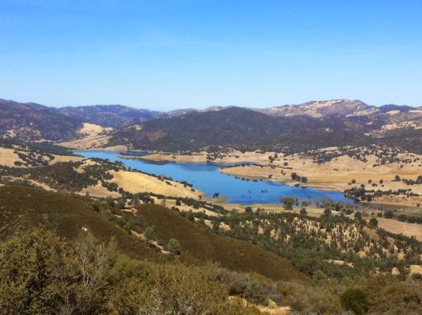
Sixty Lake Basin; photo from Leor Pantilat's Adventures


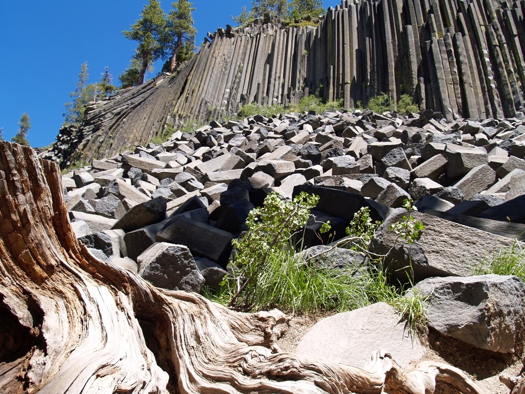
Devil's Postpile National Monument made of columnar basalt; photo from Open air and Sunshine


Flora:
There are two radically different environments to be experienced depending on elevation. Below 11,000ft (3350m) there will be lodge pole pines, jeffery pines, red firs, bristlecone pines (Inyo National Forest protects the Ancient Bristlecone Pine Forest with the oldest known living bristlecone pine on earth), and low woody shrubs, but as we climb higher the plants get closer and closer to the ground and we will begin to see alpine flowers and shrubs.
Take note and report these rare native gems: gunsight clarkia
goosefoot yellow violet
ceanothus pinetorum or kern ceanothus


Fauna:
Look out for Monache Mule Deer, Sierra Nevada Red Fox, Pine Martens, Mountain Lions, and black bears. According to some trail notes from On the Trail, there are aggressive bears between Little Pete Meadow and Big Pete Meadow camping grounds.

Rock Climbing:
There is a rock climbing spot on the other side of Owens Peak named Indian Wells Canyon. From the trail you head east to the Owen Ridge line. There looks to be climbing to be found all along the ridge back but not a lot of people frequent it because of the difficult approaches and pockets of rotted granite. There are some long routes but not hard routes. I will have to watch my hand placement, but this seems like a great place to have some adventure time.
There is a place we will be somewhat close to but still too far away to really call it "off the trail." It's the Needles/Kern River area and it's basically the Big Rock Candy Mountain of climbing in the Southern Sierra's. Routes are everywhere and you get the see the Kern River Valley which is gorgeous AND there are bouldering routes over deep water…sounds like heaven. I may have to come back and visit this one. I don't think I will have enough time to get over there, enjoy it, and get back to the trail. It's the sort of place where I would want to have a kayak, mountain bike, and climbing gear and live there for a week or two.
The Horseshoe Lake area provides numerous sport climbs, bouldering around June Lakes, bouldering in Tuolumne MeadowsLembert Dome, and alpine climbs where ever you look.

Thursday, November 14, 2013

Southern Sierra: Kiavah Wilderness and Sequoia National Park

Halfmile maps f

From Cameron Canyon Rd aka Hwy 58 aka Tehachapi Pass the trail treks up by LaRose Falls and waterfall canyon. I'm curious if the beauty matches the name and might take a trail detour to check out the area. From the looks of the map, it seems like water in the Piute Mountain Range will not be an issue on the first part of this section. As we traverse around cache peak there area is littered with springs on either side of the trail but beware hikers get sick on this section so be careful, take some extra Vitamin C, and make sure your water is clean. After this short spurt of water it goes dry so carry a lot.

From the satellite view it looks like the trail comes down into dry lands before it hikes up into the Scodie Mountain section of the Kiavah Wilderness and Sequoia National Park, south east of Lake Isabella. In the screen capture below Lake Isabella is in the top left of the screen. The PCT traverses from the Piute Mtn range on the left side of the screen, directly below Mayan Peak (point A), and then north to the green range on the top right side (the Scodie Mtns.)

Maybe there is some shade to be found around the Pinyon Mtns. Even if there isn't that much shade to be found, there may be another treat. Pine Nuts from the Pinyon Pine. For those who can eat them, they are a tasty treat.

Flora:
It looks like another hot and sunny section. Even Scodie Mtn, which is supposed to be a reprieve from the sun looks rather arid.

But don't let it fool you, the plants we get to experience here are very special. The Kiavah Wilderness is one of the two places that can support Pinyon-Juniper woodlands in CA. One can also find Mormon teaburro bush, Joshua Trees, grey pines, and a variety of wildflowers which are blooming April to June. The rare gem on this section of trail is the Walker Pass milkvetch, a endemic legume. It has only been recorded as seen three times. If you see it, please take notes and report it/ don't bother it. I will be hunting a few west facing hillsides for this little survivor.


Friday, November 8, 2013

Back to Desert: Angeles National Forest and Mojave Desert

Halfmile Project maps d and e

Angeles National Forest is the first national forest in California, historical landmark #717. Within the it rise the San Gabriel Mountains. They separate the Los Angeles Basin and the Mojave Desert and act as a water collection system for the surrounding areas. Mount "Baldy" (or Mount San Antonio) is the highest peak in Los Angeles County measuring 10, 068ft (3,069m). image from wikipedia on San Antonio. 


The National Forest has seen it's share of mishaps. You may or may not remember that in July of last year three campgrounds were closed in Angeles National Forest due to the discovery of a bubonic plague outbreak among squirrels. A fire scorched over 161,000 acres of land, that's 1/4th of the forest in August of 2009 which almost took out the Mount Wilson Observatory and the antenna farm which, among other things, broadcasts the police and fire department emergency channels. That would have sucked. The area is still in the recovery period.
Other fun facts: -Black bears are not native to this region, but in 1933 eleven rambunctious bears from Yosemite Valley were transferred here. -Baldy Camp was the hip nightlife of LA during prohibition.
The trail follows along side several sections of road, seem like map d and e are good places to have gear trouble or to strike up some conversations with day hikers or find some people with ropes to share for climbing. The trail dips down from the mountains at Aqua Dulce and then it heads back up where we tool around past Green Valley and continue to mountain roam.


Mojave Desert:

The trail descends from the mountains into Neenach, CA. From the town we will traverse through Antelope Valley, which is the western tip of the Mojave Desert. Then the trail ascends into arid mountain and canyon lands, passing through wind farms, until it exits into Cameron Canyon.
Antelope Valley was named after the abundant pronghorn sheep population, but after drought, too much snow, over hunting, etc the numbers now are few. I still hope to see one.


Flora: After spending quite a while in ponderosa, lodgepole, and jeffrey pines we will descend back into chaparral and then into sage brush and desert. The difference being we will have some new plants in the mix this time since Antelope Valley gets more rain and ground water than most. There is the California poppy (all the pictures of this massive bloom are beautiful but we will most likely miss it), the infamous Joshua Tree, the California Juniper, and many more plants that like this area.


Rock Climbing: Tunnel Crag is first to pass. It is barely out of the way and as long as there is somewhere to walk along Hwy 2. I will probably skip this one unless I meet someone with rope because it's 5.10 and 5.11 routes only. Past my free climbing comfort grades. Next up, a little more of a detour, Williamson Rock. Pretty much just sport, 5.6 -5.13. It looks real beautiful.


I'm most excited about Horse Flats. It just looks fun to mess around in with lots of bouldering and some trad climbs. Maybe a good place to take a climbing 0 day?

Wednesday, November 6, 2013

Sky Islands: San Jacinto Mtns and San Bernardino NF

Halfmile Project map section b and c. image from tree hugger international.

The trail traverses through San Jacinto Mountain Game Reserve, San Jacinto State Wilderness, San Jacinto State Park. The range is granite rock wedged between the San Jacinto Fault and the San Andreas Fault, sounds like perfect territory for finding some climbing along the way. Also rock slides could happen if a major earthquake occurs.
Along with the San Bernardino Mtns, the San Jacinto Mtns are humid islands in a sea of dry, desert. Most of the rain occurs from November to March, but thunderstorms can cause flash flooding mid July to mid September. Snow can persist above 8,000ft (about 2,440m) till June and above 9,000ft (about 2,750m) you will see some patches of snow all year.
Get ready for some aerobics, this mountain range goes from sea level to 10,000ft (about 3050m) in a few measly miles. It will be a wake up call to the legs. Hopefully by then our packs will be all light and figured out. Remember elevation gain and the temperature change will make us need more food and water.

Flora:
From the desert, the trail starts to climb through sage brush, chaparral (see last post for definition), and, as you climb higher, through pine trees. Above about 5,500ft (about 1680m) we will start to see ponderosa pines, lodgepole pines, jeffrey pines, incense cedars, white firs, and red firs. Between the slabs of granite rock and pines and cooler temps, it will feel like CO.
Special Interest:
Tahquitz Peak (8,750 feet/2667 meters)On the way through, I want to check out this classic climbing. Tanquitz and Suicide Rock are both above Idyllwild. It's all multi pitch and so I might not be able to do too much but I will go and free solo parts of the easier routes. Really I would just be psyched to be there. There is also a bouldering area in Idyllwild County Park and you can even camp next to some good bouldering (sites 55-78, save me a spot.)

San Bernardino Nation Forest. image from parks website


Welcome to gold rush territory. The San Bernardino Mtns have a long history in resource management. It was over logged, mined, and has been used as a water source to the surrounding cities for a long time. In the 1900s the range was made a national forest and it still used as a reservoir to supply water to the dry, urban areas surrounding them. The California Aqueduct runs through as well as a few highways. 

The Mtns provide the most reliable powder south of the Sierra's so ski resorts are common. They have the same rainy/snowy seasons as the San Jacinto Mtns, but the San Bernardino's are more likely to have snow since they often get more precipitation and are generally higher.
Erosion is a huge problem here, probably because it is right on the San Andreas Fault and people have been poking around for a long time. Sediment and rock erode and deposit in massive alluvial fans. These act as water highways into the groundwater basins below. Be wary if it is storming, these alluvial areas flash flood. Side note, crossing a wide alluvial channel, balancing from rock to rock, can really get annoying on the knees.

From the San Jacinto Mtns. The trail dips down into San Gorgonio Pass (by Cabazon), skirts around the sides of some San Bernardino Mtns, then head down again into Whitewater Canyon, and then follows a canyon vein back up into the Mtns, heads through alpine basin territory, and then checks out Big Bear Lake and later Silverwood Recreation Area.

Fauna: On the endangered end of the animal spectrum there is the San Bernardino flying squirrel, California spotted owl, Mountain yellow-legged frog, Southern Rubber Boa, and Andrew's Marbled Butterfly. Please make notes and report if you see any of these.

Special Interest: There is a load of climbing to be done by Big Bear Lake, from bouldering to trad and sport. I'll probably head to North Shore Boulders and The Gardens for a nice V0-2 warm up and then trek over to Holcomb Valley Pinnacles and Central Pinnacles area to check out some routes that are along the PCT. 


Sunday, November 3, 2013

Desert: Cleveland NF and Anza-Borrego Desert SP

Knowledge about the landscape in which I am traversing broadens my hiking experience. It gives my mind something to latch onto while walking and helps me remember landscape diversity more intensely. For these reasons, I will be going through each major forest, recreation area, mountain chain, etc we will be facing starting on the Mexican border. If you want to cross reference the info with a map, I am using the Halfmile Project maps. 

First up is the southernmost forest in California, Cleveland National Forest. This is 20 miles from the start of the trail, most know it for Lake Morena and the Annual Zero Day Pacific Crest Trail Kick Off (AZDPCTKO, hope to see you there.) picture below from the forest service website.

Flora:
Cleveland National Forest is apart of the chaparral ecoregion. Chaparral is basically dense shrubland. The plants are woody, dry, and highly flammable. It acts as a perfect breading ground for wild fires to spread and affect large areas so we need to be careful. In 2013 there was a fire that scorched 1,500 acres of forrest land. 
The indicator plants of chaparral ecoregion are scrub oaks, Bishop Pines, Monterrey Pines, Knobcone Pines. It may be green, but keep close tabs of the amount of water you are using and the nearest water sources.

Points of Interest:
The trail goes from Cleveland NF to Laguna Mtn Recreation Area. Below is a picture from the US Dept of Interior Bureau of Land Management page that shows the view of Hernandez Reservoir from Laguna Mtn. It shows how the dry land land meets the chaparral ecoregion.


Anza-Borrego Desert State Park will be next. It is the largest state park in CA. This place looks so beautiful and brutal. I mean, just look at this…

For beauty, there nothing quite like the desert. Waking up to an early sunrise in Utah taught me that. I'm excited and scared for this part of the journey. Growing up in Burkina, I struggled with frequent headaches from the suns intensity. In the Western Cape of South Africa, I wore a long sleeves, a hood, and sunglasses to keep the sun off and my eyes safe, but I still would be "sunned out." It just wears on me after a while. What can I say, I'm sensative and that means, I'm also nervous. I should be worried about water, and I am, but not as much as I'm worried about the sun exposure and keeping a good attitude. The desert could be my achilles heal. I have hiked with out water for a little over 24 hours and been fine, but the sun always gets to me. I will have to find ways to cope. That's part of the reason I'm so keen on hiking at night, possibly all night, more likely until I can't anymore, sleep a couple hours, get up early, hike until really hot, sleep, and do it all over again. 
The desert used to be a marine environment. Maybe I will be lucky enough to find a good fossil (to look at, not to take or touch.) Really what I am hoping to see are the Desert Bighorn Sheep and some pre-columbian rock art. 

Flora:
A variety of cacti and sage are common. An oasis my have the endangered native californian palm tree. Other trees include the smoke tree (a grey/mint colored tree with small wispy branches from which is gets it's common name,) the velvet mesquite (a green, small leaved tree which may provide some shade,) and the lovely cat claw (don't want to get tangled in with those thorns. Remember, they are hooks, so be patient when getting gear untangled.)

Points of Interest:
I'm a climber, so anytime I see something climbable off the PCT I will probably try it out. There are a couple places that I think we might be coming close to on the Anza-Borrego Desert section (comparing between Halfmile Project and the Mountain Project Maps is not a super accurate way for seeing how far climbing locations are from the trail.) It would be sweet to check out some bouldering at Gilligan's Island, Culp Valley, and a place that only has the name random area just south of Culp. below is a picture of a V4 problem in Culp Valley


Saturday, November 2, 2013

Desert: General Overview

On my run today I started thinking about food on the hike, but then realized I was getting ahead of myself in planning. I shifted my thoughts over to the climates we will face on the PCT. For most of us, that will be starting in the desert.

The amount of dry territory thru hikers must cover is daunting. Take it from someone who grew up in Burkina Faso, heat can make you a bit loopy. The unforgiving sun, the constant cotton mouth, the desire for just a little bit of shade, the lack of privacy (low and sparse brush)  I'm excited for all of it. At least it is dry heat. That makes it feel not quite like 100F.

Temperatures should range between 50-120F (10-49C). In April the Pacific brings storms but the area is pretty dry by mid May. The trail follows the mountain range mostly, going through the San Jacinto Mtns, the San Bernardino Mtns, and the San Gabriel Mtns where pines should make for a much welcome respite.

The obvious problems in the desert are sun, heat, and water. I will hike nocturnally and only be eating uncooked/previously prepped food to save my skin, water, and weight (I won't have to carry a cooking system for awhile, if I really start missing it I can have someone send it to me.)

I feel like after all of this I need to inspire myself. The desert is typically where people go to find themselves. You mind starts mimicking the landscape; there is no place to hide. What is often considered infertile ground becomes a place for plants to adapt and specialize against all odds. This landscape is the perfect metaphor for the beginning of our journey.

"Time and space. In the desert there is space. Space is the twin sister of time. If we have open space then we have open time to breath, to dream, to dare, to play, to pray to move freely, so freely, in a world our minds have forgotten but our bodies remember. Time and space. This partnership is holy. In these redrock canyons, time creates space--an arch, an eye, this blue eye of sky. We remember why we love the desert; it is our tactile response to light, to silence, and to stillness." - Terry Tempest Williams, Red: Passion and Patients in the Dessert

"“I’ve crossed these sands many times,” said one of the camel drivers one night. “But the desert is so huge, and the horizons so distant, that they make a person feel small, and as if he should remain silent.” (76) Paulo Coelho, The Alchemist


"Lion King" shows how his trip began and shares about the brutal heat.
http://www.youtube.com/v/AM1V-JZit5M?version=3&autohide=1&feature=share&autoplay=1&autohide=1&attribution_tag=gRl_FbX6GWFCyH5Op_WZGA&showinfo=1

Friday, November 1, 2013

How to decide...

For some, making the choice to complete the Pacific Crest Trail is a way to leave an old life behind. It's about a commitment to change. Some want to depart from the cooperate world, others want to realize their strength. For me, it's not a new beginning, it's continuing on my current path.
After graduating college, I worked on Kauai, then completed residencies in Canada, traveled to South Africa, went to Colorado, completed the Tuscurora Trail, worked and hiked and climbed in Colorado, climbed in Utah, climbed and hiked in Wyoming, road tripped through Montana up to Minnesota, kayaked and fished in Minnesota, climbed in Michigan, and now I'm saving up money for next year. It has been a life I have loved for a year and a half. 
I had considered thru hiking before, but always thought about how hard it must be on your body and how different a month long trip is from a 5 month long trip. I thought I would be able to get more exploring done by not thru hiking. How this changed is probably very revealing. I was sick with a stomach bug one night this week and was watching anything to do with climbing/mountaineering on Netflix and then I saw Ride the Divide pop-up in my suggestions. My brother is mountain biker and had talked to me about it before. I watched it and then did some research on the Continental Divide Trail. An ad came up on the top of my google search for "Hike for Mental Health : Thruhikers needed 2014." My uncle suffers from schizophenia so I was curious and I clicked on it. The website got my cogs turning and next thing you know I'm printing out maps and planning resupply points. 
I have a tendency to be a bit bullheaded; I decide something and move forward full force, but this time I'm trying to be a bit more cautious. I'm planning and reading, giving myself a couple weeks before I truly decide whether to do it full force. 
While looking around, there are some great sources for what to do on the trail. I will hopefully cover that in this blog as well, but I sense that where information is lacking is what to do and the mental battles that happen before you break dirt on the Pacific Crest Trail. I will try and help others through this section as I'm sure there are many who are in that "on the fence" stage for the 2014 season. 

Look at my Hike for Mental Health profile page.