First up is the southernmost forest in California, Cleveland National Forest. This is 20 miles from the start of the trail, most know it for Lake Morena and the Annual Zero Day Pacific Crest Trail Kick Off (AZDPCTKO, hope to see you there.) picture below from the forest service website.

Flora:
Cleveland National Forest is apart of the chaparral ecoregion. Chaparral is basically dense shrubland. The plants are woody, dry, and highly flammable. It acts as a perfect breading ground for wild fires to spread and affect large areas so we need to be careful. In 2013 there was a fire that scorched 1,500 acres of forrest land.
The indicator plants of chaparral ecoregion are scrub oaks, Bishop Pines, Monterrey Pines, Knobcone Pines. It may be green, but keep close tabs of the amount of water you are using and the nearest water sources.
Points of Interest:
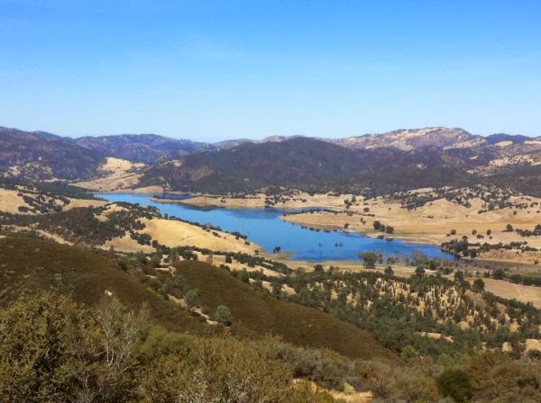
The trail goes from Cleveland NF to Laguna Mtn Recreation Area. Below is a picture from the US Dept of Interior Bureau of Land Management page that shows the view of Hernandez Reservoir from Laguna Mtn. It shows how the dry land land meets the chaparral ecoregion.
Anza-Borrego Desert State Park will be next. It is the largest state park in CA. This place looks so beautiful and brutal. I mean, just look at this…

For beauty, there nothing quite like the desert. Waking up to an early sunrise in Utah taught me that. I'm excited and scared for this part of the journey. Growing up in Burkina, I struggled with frequent headaches from the suns intensity. In the Western Cape of South Africa, I wore a long sleeves, a hood, and sunglasses to keep the sun off and my eyes safe, but I still would be "sunned out." It just wears on me after a while. What can I say, I'm sensative and that means, I'm also nervous. I should be worried about water, and I am, but not as much as I'm worried about the sun exposure and keeping a good attitude. The desert could be my achilles heal. I have hiked with out water for a little over 24 hours and been fine, but the sun always gets to me. I will have to find ways to cope. That's part of the reason I'm so keen on hiking at night, possibly all night, more likely until I can't anymore, sleep a couple hours, get up early, hike until really hot, sleep, and do it all over again.
The desert used to be a marine environment. Maybe I will be lucky enough to find a good fossil (to look at, not to take or touch.) Really what I am hoping to see are the Desert Bighorn Sheep and some pre-columbian rock art.
Flora:
A variety of cacti and sage are common. An oasis my have the endangered native californian palm tree. Other trees include the smoke tree (a grey/mint colored tree with small wispy branches from which is gets it's common name,) the velvet mesquite (a green, small leaved tree which may provide some shade,) and the lovely cat claw (don't want to get tangled in with those thorns. Remember, they are hooks, so be patient when getting gear untangled.)
Points of Interest:
I'm a climber, so anytime I see something climbable off the PCT I will probably try it out. There are a couple places that I think we might be coming close to on the Anza-Borrego Desert section (comparing between Halfmile Project and the Mountain Project Maps is not a super accurate way for seeing how far climbing locations are from the trail.) It would be sweet to check out some bouldering at Gilligan's Island, Culp Valley, and a place that only has the name random area just south of Culp. below is a picture of a V4 problem in Culp Valley

No comments:
Post a Comment